UNIVERSAL ENGINEERING
LOCATIONS:
|
| |
|
CONCRETE IMAGING SYSTEM
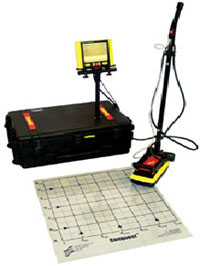
The Conquest™ Concrete Imaging System, ground penetrating radar, is capable of scanning from 24" to 96" square areas to a depth of up to 24 inches. Each scanned area produces several plan views, which represents 1.2" thick layers throughout the depth of the scan. 4 Easy Steps to Imaging:
Layout survey grid on area surface. Select the image parameters. Scan the grid with the radar system. View and analyze the images.
|  |
In contrast to radiography, Conquest™ does not require evacuation of the work area, and only needs access to one side of the structure. Conquest™ provides the best and most cost-effective non-destructive concrete evaluation solution on the market.
|
|
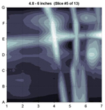
Plan View | The plan view to the left is from a 2' square survey grid. Seven (7) lines at 4" intervals were scanned for a length of 24" in each direction. Scanned lines are designated as lines 1 through 7 and A through G with 4" between each line. The Conquest system uses the data and generates several images each representing 1.2" thick slices of the 2' square area. The image to the left represents the slice between 4.8" to 6.0" and reveals post tension cables with a splice chuck.
Click HERE to view all the layers from this survey.
|
Floor Slab with Void
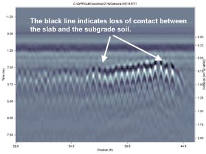
Side View
Concrete slabs can be scanned, using the ground penetrating radar, to determine presence of voids in or under a slab. The image above indicates loss of contact between the slab and the underlying soils between the 35 foot to 44 foot position as referenced from the 0' position or starting point of the scan.
|
|
|
Wire Mesh in Floor Slab
Plan View
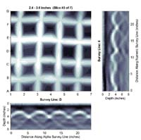
Side view
The image above is a 24" square scan on a residential floor slab. This scan revealed 6" grid wire mesh at approximately 2" below the surface of the slab.
|
|
Concrete Reinforcment Image, Side View
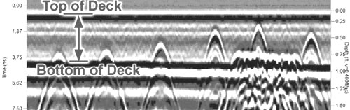
The peaks of the hyperbolas(^) indicate the location and depth of the embedded items.
This image is from an elevated Parking Deck indicating embedded steel locations and depths.
Note the extensive reinforcement at the column line. Groud Penetrating Radar surveys can be used to reduce the chances of damaging vital structural steel, tension cables, plumbing or electrical conduit when drilling or cutting through concrete slabs. GPR scanning can also provide verification of embedded item locations and depths as well as verifying adequate coverage of reinforcement steel.
|
Masonry Wall Image
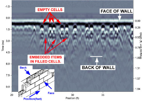
Masonry Walls can be scanned to locate filled cells and embedded rebar in the filled cells. The Ground Penetrating Radar unit is also capable of producing single line scans for long distances. Each scan provides images displaying location and depth of detected embedded items. Project data can be saved on digital media (CD/DVD) if required or it can be posted in a private folder on the Internet for select Audience review.
|
copyright© 2015
Site by compurelief.net
|
 UNIVERSAL ENGINEERING SCIENCES